Mapping forest aboveground biomass with a simulated ICESat-2 vegetation canopy product and Landsat data
Introduction: The assessment of forest aboveground biomass (AGB) can contribute to reducing uncertainties associated with the amount and distribution of terrestrial carbon. The Ice, Cloud and land Elevation Satellite-2 (ICESat-2) was launched on September 15th, 2018 and will provide data which will offer the possibility of assessing AGB and forest carbon at multiple spatial scales.
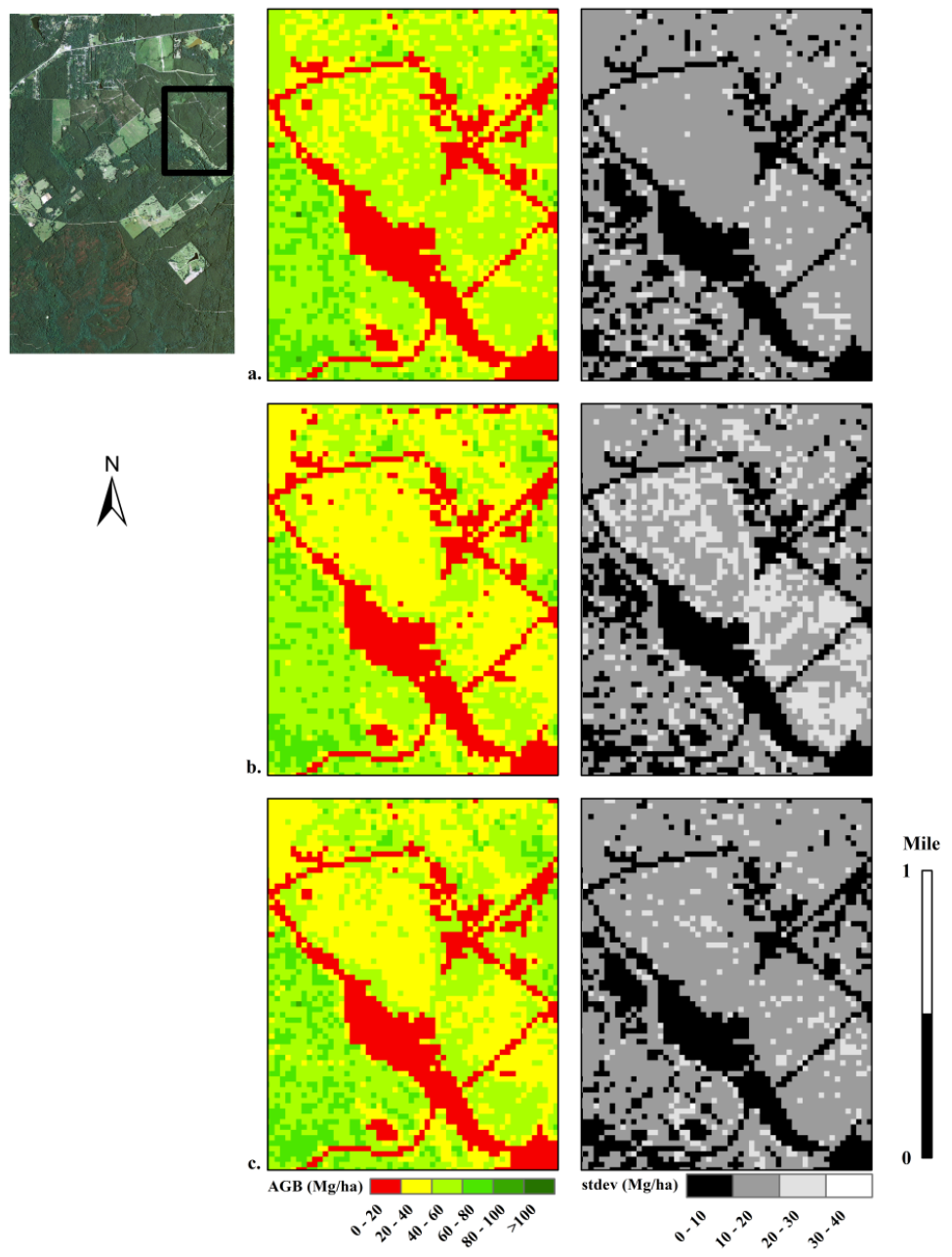
Goal: The primary goal of this study was to develop an approach for utilizing data similar to ICESat-2’s land-vegetation along track product (ATL08) to generate wall-to-wall AGB maps.
How: Utilizing simulated daytime and nighttime ICESat-2 data from planned ICESat-2 tracks over vegetation conditions in south-east Texas, we investigated the integration of Landsat data and derived products for AGB model and map production. Linear regression models were first used to relate simulated photon-counting lidar (PCL) metrics for 100 m segments along ICESat-2 tracks to reference airborne lidar-estimated AGB over Sam Houston National Forest (SHNF) in south-east Texas. Random Forest (RF) was then used to create AGB maps from predicted AGB estimates and explanatory data consisting of spectral metrics derived from Landsat TM imagery and land cover and canopy cover data from the National Land Cover Database (NLCD).
Highlights:
Using RF, AGB and AGB uncertainty maps produced at 30 m spatial resolution represented three data scenarios;
(1) simulated ICESat-2 PCL vegetation product without the impact of noise (no noise scenario),
(2) simulated ICESat-2 PCL vegetation product from data with noise levels associated with daytime operation of ICESat-2 (daytime scenario), and
(3) simulated ICESat-2 PCL vegetation product from data with noise levels associated with nighttime operation of ICESat-2 (nighttime scenario).
The RF models exhibited moderate accuracies (0.42 to 0.51) with RMSE values between 19 Mg/ha to 20 Mg/ha with a separate test set. The adoption of a combinatory approach of simulated ICESat-2 and Landsat data could be implemented at larger spatial scales and in doing so, ancillary data such as climatic and topographic variables may be examined for improving AGB predictions.